To search a specific address, launch the interactive map and enter the address. The map will zoom in to the address -- click on that location to learn more about the District in which that address is located. The map shows both legacy (existing) boundaries and new boundaries that will be phased in based on the next scheduled election for each specific district term.
Please contact the District Secretary’s Office at 510-464-6083 with any questions about the new interactive map.
BART 2022 Election Districts Final Report
BART election districts are redrawn every 10 years following the U.S. Census. The BART Board of Directors voted to approve new maps on March 10, 2022. View details of the 2022 Redistricting process.
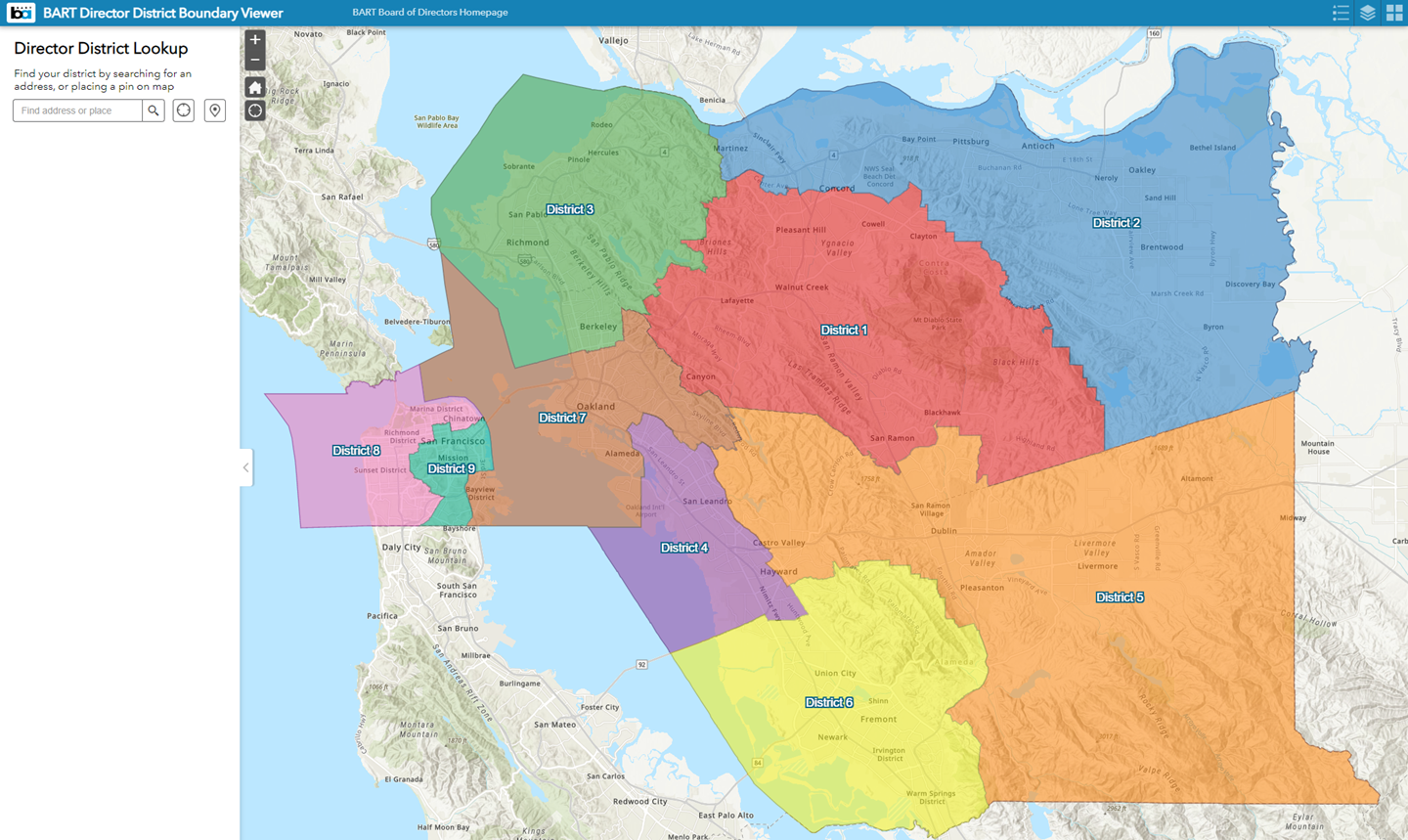
All BART Districts
Counties Included: Alameda, Contra Costa, San Francisco
Maps:
All BART Districts
District: 1
Counties Included: Contra Costa
Cities Included: Acalanes Ridge, Alamo, Alhambra Valley, Blackhawk, Camino Tassajara, Castle Hill, Clayton, Concord (partial), Contra Costa Centre, Danville, Diablo, Lafayette, Martinez (partial), Moraga, North Gate, Orinda, Pleasant Hill, Reliez Valley, San Miguel, San Ramon (partial), Saranap, Shell Ridge, Unincorporated Contra Costa County (partial), Walnut Creek
Map: BART District 1 (.pdf file)
District: 2
Counties Included: Contra Costa
Cities Included: Antioch, Bay Point, Bethel Island, Brentwood, Byron, Concord (partial), Clyde, Discovery Bay, Knightsen, Martinez (partial), Mountain View, Oakley, Pacheco, Pittsburg, Unincorporated Contra Costa County (partial), Vine Hill
Map: BART District 2 (.pdf file)
District: 3
Counties Included: Alameda, Contra Costa
Cities Included: Albany, Bayview, Berkeley, Crockett, East Richmond Heights, El Cerrito, El Sobrante, Hercules, Kensington, Pinole, Montalvin Manor, North Richmond, Port Costa, Richmond, Rodeo, Rollingwood, San Pablo, Tara Hills, Unincorporated Contra Costa County (partial)
Map: BART District 3 (.pdf file)
District: 4
Counties Included: Alameda
Cities Included: Ashland, Cherryland (partial), Hayward (partial), Oakland (partial), San Leandro (partial), San Lorenzo
Map: BART District 4 (.pdf file)
District: 5
Counties Included: Alameda, Contra Costa
Cities Included: Castro Valley, Cherryland (partial), Dublin, Fairview (partial), Hayward (partial), Livermore, Norris Canyon, Oakland (partial) Pleasanton (partial), San Leandro (partial), San Ramon (partial), Sunol (partial), Unincorporated Alameda County (partial), Unincorporated Contra Costa County (partial)
Map: BART District 5 (.pdf file)
District: 6
Counties Included: Alameda
Cities Included: Fairview (partial), Fremont, Hayward (partial), Newark, Pleasanton (partial), Sunol (partial), Union City, Unincorporated Alameda County (partial)
Map: BART District 6 (.pdf file)
District: 7
Counties Included: Alameda, San Francisco
Cities Included: Alameda, Berkeley, Emeryville, Oakland (partial), Piedmont, San Francisco (partial), Unincorporated Alameda County (partial)
Map: BART District 7 (.pdf file)
District: 8
Cities Included: San Francisco (partial)
Counties Included: San Francisco
Map: BART District 8 (.pdf file)
District: 9
Cities Included: San Francisco (partial)
Counties Included: San Francisco
Map: BART District 9 (.pdf file)