Search Results
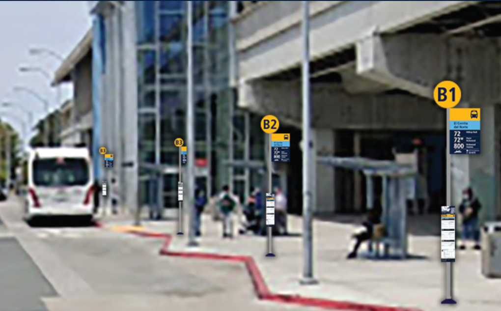
El Cerrito del Norte Station: Installation of new signs and maps for testing
Starting Monday, November 18, 2024, signage and maps will be installed at El Cerrito del Norte Station to test new regional transit standards. Construction will take approximately three weeks and is not likely to impact passengers.
This work will include select station identification, elevator, bus stop, and new line diagram signage, as well as new maps.
Once complete, we’ll ask you to share your feedback on these test signs and maps and how we can make them work better for you. Your ideas will help us improve designs to make traveling by transit more intuitive, convenient and fun!
This is part of the Regional Mapping & Wayfinding Project, which will harmonize maps and signs to help people navigate transit throughout the Bay Area. It is led by the Metropolitan Transportation Commission, in collaboration with BART and all Bay Area transit agencies.
Learn more about the project at: https://mtc.ca.gov/MappingWayfinding
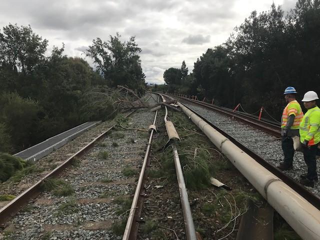
Single Tracking and no Green Line Alert: Vegetation management work planned until noon on Sunday, November 9, between Union City and Bay Fair stations
BART workers on the morning of Sunday, November 9, will manage vegetation that could threaten our ability to provide safe and reliable service. Service from 8am to noon will be reduced from two tracks to one between Union City and Bay Fair. Trains will run every 40 minutes between the two stations while the work is happening. There will also be no Green Line service until 1pm. Riders should consider starting their trips at Bay Fair Station, where Blue Line service will still be offered in addition to the Orange Line. Orange, Yellow, Blue, and Red lines will be running, and all 50 stations will be open.
Service must be reduced to one track to provide crews with enough space to finish this essential work safely and as quickly as possible. This work is happening after a tree fell into the trackway on October 15 near Union City Station and interrupted service for several hours.
Appropriations Limit for Fiscal Year 2026 Notice of Documentation for Review and Time of Meeting
Notice is Hereby Given That:
A. Documentation used in determining the District’s appropriations limit for the fiscal year July 1, 2025 to June 30, 2026, will be available for public review on and after May 7, 2025. Please see the links below.
Appropriations Limit Resolution
Appropriations Limit Attachment 1
Appropriations Limit Attachment 2
B. At its scheduled meeting on Thursday, May 22, 2025, at 9:00 a.m. in the Board Room, 2150 Webster Street, First Floor, Oakland, CA 94612, the Board of Directors will address the District’s appropriations limit for Fiscal Year 2026. Any person may appear there and be heard regarding this matter.
Comments may be made at the hearing or should be sent to:
Robert Franklin, District Secretary (Interim)
San Francisco Bay Area Rapid Transit District
2150 Webster Street, 10th Floor
Oakland, California 94612
[email protected]
Appropriations Limit for Fiscal Year 2027 Notice of Documentation for Review and Time of Meeting
Notice is Hereby Given That:
Documentation used in determining the District’s appropriations limit for the fiscal year July 1, 2026 to June 30, 2027, will be available for public review on and after May 13, 2026. Please see the links below.
Appropriations Limit Resolution
Appropriations Limit Attachment 1
Appropriations Limit Attachment 2
At its scheduled meeting on Thursday, May 28, 2026, at 9:00 a.m. in the Board Room, 2150 Webster Street, First Floor, Oakland, CA 94612, the Board of Directors will address the District’s appropriations limit for Fiscal Year 2027. Any person may appear thereat and be heard regarding this matter.
Comments may be made at the hearing or should be sent to:
Robert Franklin, District Secretary
San Francisco Bay Area Rapid Transit District
2150 Webster Street, 10th Floor
Oakland, California 94612
[email protected]
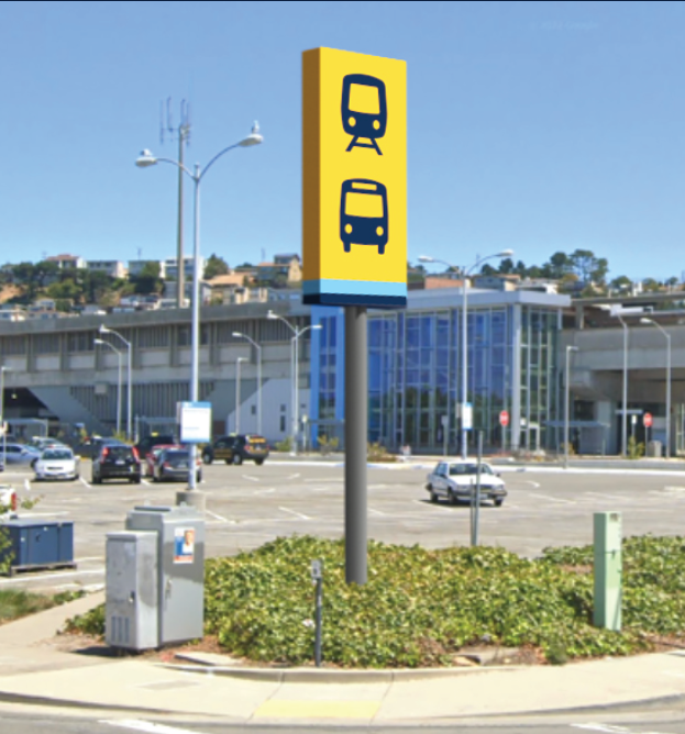
Take a first look at the new standardized designs coming to Bay Area transit maps and signs
A new, uniform look for transit maps and signs in the Bay Area is almost here.
The new transit maps and signs are designed to make transit journeys easier to understand for existing and new riders by delivering information that is clear, predictable, and familiar across service areas and county lines.
These new maps and signs — which include local transit and facility maps, diagrams, and bus stop signs — mark another step forward in Bay Area transit’s transformation into a more connected, more efficient, and more customer-focused mobility network.
Transit agency and Metropolitan Transportation Commission staff will present the designs next week at the Sept. 23 meeting of the Regional Network Management Council.
Members of the public are invited to attend the Regional Network Management meeting on Monday, Sept. 23, at 12:30 p.m. in person or online to learn more about the maps and signage, and their installation later this fall at transit hubs in El Cerrito and Santa Rosa.
Details about the meeting are available on the MTC website. This information also will be presented to the Regional Network Management Customer Advisory Group at its meeting on Tuesday, Sept. 24.
The new bus stop signs and suite of maps focuses on service frequency and uses standardized colors, line styles, and labels on maps and signs to indicate how often a bus, train or ferry arrives at a particular stop. They also show bus lines whose schedules are coordinated to provide more service.
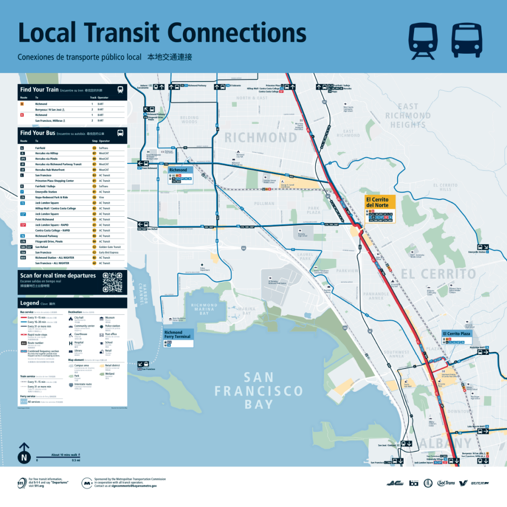
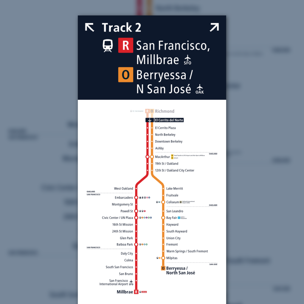
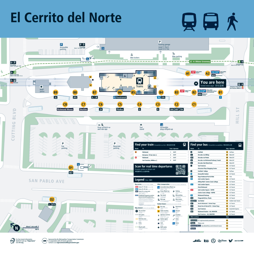
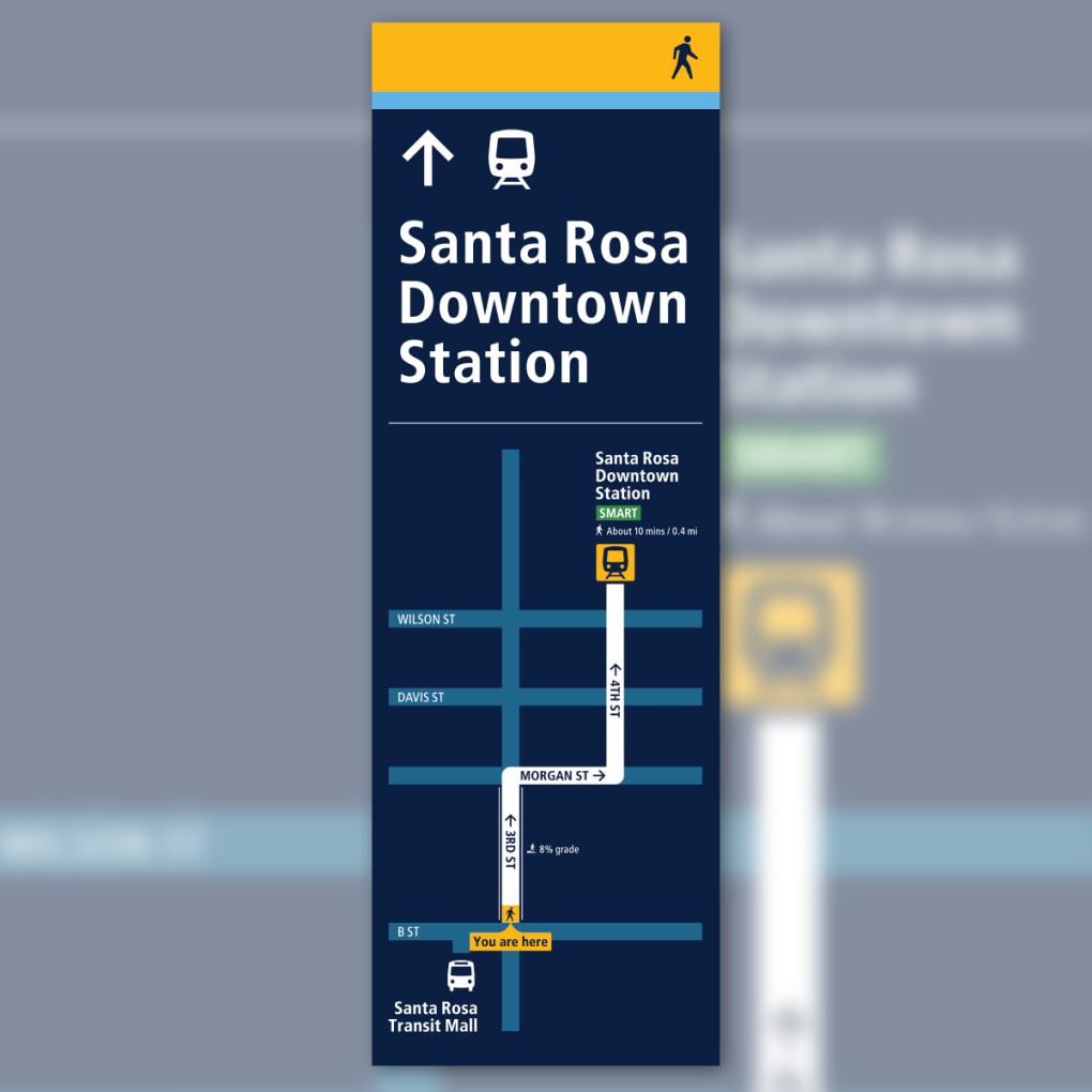
This fall MTC and its partners will invite Bay Area residents and visitors alike to share their thoughts about the newly designed transit signs and maps once they are installed at the Santa Rosa Transit Mall, the nearby Santa Rosa SMART station, and the El Cerrito del Norte BART station. A new, comprehensive regional transit map, which will enable riders to discover key destinations they can reach on the Bay Area's extensive bus, rail and ferry network, also will be released.
Riders will be able to interact with several test signs, maps and other communication materials at the Santa Rosa and El Cerrito locations and then provide comments about their experiences. The public feedback will help inform the next stage of the project, in which the new maps and wayfinding materials are expected to be installed at seven additional locations across the Bay Area in 2025 and 2026.
The new maps and signs are part of the larger Regional Mapping and Wayfinding initiative aimed at making it easier to ride transit in the Bay Area. Whether a rider is traveling by bus, rail, ferry or a combination, the signs, maps, screens and other communication systems will be consistent and easy to identify across all nine Bay Area counties.
The Regional Mapping and Wayfinding Project is the result of a first-of-its-kind effort, led by MTC with the partnership of transit riders, Bay Area cities and counties, and all 27 Bay Area transit agencies, to develop a common set of signs and maps to be used across all transit locations, from individual bus stops to major hubs where multiple systems connect. This project is just one piece of a broader effort, outlined by the Bay Area Transit Transformation Action Plan, focused on making Bay Area transit easier and more convenient for riders of all ages and abilities to use.
The Regional Network Management Council includes top executives from MTC, the San Francisco Municipal Transportation Agency, BART, AC Transit, the Santa Clara Valley Transportation Authority (VTA), Caltrain, SamTrans and the Golden Gate Bridge, Highway and Transportation District as well as three general managers representing all other transit agencies serving Bay Area communities.
MTC is the transportation planning, financing and coordinating agency for the nine-county San Francisco Bay Area.
Appropriations Limit for Fiscal Year 2025 Notice of Documentation for Review and Time of Meeting
Notice is Hereby Given That:
A. Documentation used in determining the District’s appropriations limit for the fiscal year July 1, 2024 to June 30, 2025, will be available for public review on and after May 8, 2024 at the Office of the District Secretary, Tenth Floor, 2150 Webster, Oakland, California.
Appropriations Limit Resolution
Appropriations Limit Attachment 1
Appropriations Limit Attachment 2 (revised)
B. At its scheduled meeting on Thursday, May 23, 2024, at 9:00 a.m. in the Board Room, 2150 Webster Street, First Floor, Oakland, CA 94612, the Board of Directors will address the District’s appropriations limit for Fiscal Year 2025. Any person may appear thereat and be heard regarding this matter.
Comments may be made at the hearing or should be sent to:
April Quintanilla, District Secretary
San Francisco Bay Area Rapid Transit District
2150 Webster Street, 10th Floor
Oakland, California 94612
[email protected]
Downtown Berkeley Station: elevator work on Tuesday, April 15
In advance of the renovation of the elevators at our Downtown Berkeley Station, crews will conduct a site visit on Tuesday, April 15, 2025 to get measurements, pictures and other related information.
As a result, between 10am and 2pm that day, the elevators will be shut down in 20 minute increments. This will be the case at both the street to concourse level elevator, as well as the concourse to platform level elevator. The elevators will remain operational the entire day, but there may be times when riders will be asked to wait to board while the preliminary renovation work is being done. Signage will be posted.
To check if an elevator is in service before arriving at a station, please call 510-834-LIFT (510-834-5438) or 888-2-ELEVAT (888-235-3828), or sign up for elevator status alerts at www.bart.gov/elevators. If you arrive at any station and find that the elevator(s) are out of service, you may contact a Station Agent to arrange for a lift van to take you to a nearby station with a working elevator.