Search Results
Installation work to begin January 10 for Next Generation Fare Gates at Embarcadero Station
On January 10, BART will begin the installation of Next Generation Fare Gates on the concourse level of Embarcadero Station. The installation work will happen in stages so riders can continue to use the remaining current gates while new ones are being installed. There will be additional BART staff as well as signage to direct riders to the open gates. Installing each new array is expected to take up to two weeks to complete.
A temporary barrier will be installed around each array when it is replaced to provide a safe workspace for the installation team as well as to protect riders from construction. The work will not impact train service, but riders may experience a few extra minutes wait to pass through the fare gates during peak travel hours.
The latest work comes after BART has successfully installed Next Generation Fare Gates at 15 other stations across the system. All 50 BART stations will have new fare gates by the end of 2025. You can learn more about BART’s Next Generation Fare Gate project here.

Installation work to begin week of February 14 for Next Generation Fare Gates at Rockridge Station
The week of February 14, BART will begin the installation of Next Generation Fare Gates on the concourse level of Rockridge Station. The installation work will happen in stages so riders can continue to use the remaining current gates while new ones are being installed. There will be additional BART staff as well as signage to direct riders to the open gates. The installation of each new array is expected to take up to two weeks to complete.
A temporary barrier will be installed around each array when it is ready to be removed to provide a safe workspace for the installation team as well as to protect riders from construction. The work will not impact train service, but riders may experience a few extra minutes wait to pass through the fare gates during peak travel hours.
The latest work comes after BART has successfully installed Next Generation Fare Gates at 18 stations across the system. All 50 BART stations will have new fare gates by the end of 2025. You can learn more about BART’s Next Generation Fare Gates project here.
Installation work to begin September 14th for Next Generation Fare Gates at Oakland International Airport Station
Installation of Next Generation Fare Gates is scheduled to begin September 14th at Oakland International Airport Station. The installation process is expected to take approximately two weeks to complete. This work comes after the successful installation of Next Generation Fare Gates at Civic Center, Fruitvale, and West Oakland stations.
During construction, there will be a barrier around the existing station gate array. Riders will use two temporary accessible gates to enter and exit Oakland International Airport Station. Carpet will be installed immediately before the entrance to each fare gate, to make these two gates easier to locate for riders with visual impairments. The removal of the old gates and installation of Next Generation Fare Gates will not impact BART service to Oakland International Airport.
All BART stations will have new fare gates by the end of 2025. You can learn more about BART’s Next Generation Fare Gate project at bart.gov/about/projects/fare-gate. Riders can provide feedback about the new gates at bart.gov/comments.
Installation work to begin April 30 for Next Generation Fare Gates at Daly City Station
On Wednesday, April 30 BART will begin the installation of Next Generation Fare Gates on the concourse level of Daly City Station. The installation work will happen in stages so riders can continue to use the remaining gates while new ones are being installed. There will be additional BART staff as well as signage to direct riders to the open gates. The installation of each new set of gates is expected to take up to two weeks to complete.
A temporary barrier will be installed around each array when it is ready to be removed to provide a safe workspace for the installation team as well as to protect riders from construction. The work will not delay train service, but riders may experience a few extra minutes wait to pass through the fare gates during peak travel hours.
The latest work comes after BART has successfully installed Next Generation Fare Gates at 29 stations across the system. All 50 BART stations will have new fare gates by the end of 2025. You can learn more about BART’s Next Generation Fare Gates project here.
Installation work to begin April 30 for Next Generation Fare Gates at North Concord Station
On Wednesday, April 30 BART will begin the installation of Next Generation Fare Gates on the concourse level of North Concord Station. The installation work will happen in stages so riders can continue to use the remaining gates while new ones are being installed. There will be additional BART staff as well as signage to direct riders to the open gates. The installation of each new set of gates is expected to take up to two weeks to complete.
A temporary barrier will be installed around each array when it is ready to be removed to provide a safe workspace for the installation team as well as to protect riders from construction. The work will not delay train service, but riders may experience a few extra minutes wait to pass through the fare gates during peak travel hours.
The latest work comes after BART has successfully installed Next Generation Fare Gates at 29 stations across the system. All 50 BART stations will have new fare gates by the end of 2025. You can learn more about BART’s Next Generation Fare Gates project here.
Parking News
Fleet of the Future now projected to come in hundreds of millions of dollars under budget
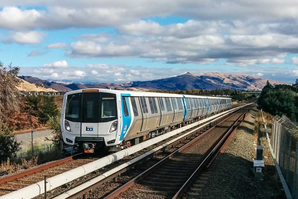
BART’s Fleet of the Future trains are now not only carrying riders on all regularly scheduled trips, but the project also is coming in hundreds of millions of dollars under budget thanks to tight project management.
Thanks to a revised schedule, and an accelerated monthly delivery rate of new rail cars, the project is expected to cost $394 million less than when the contract was awarded in 2012.
“There’s no question the Fleet of the Future project is a success story,” said Project Manager John Garnham. “Riders love the newer, cleaner modern feel of the cars and now we have great budget news for the project.”
The original contract awarded for 775 cars forecast a project cost of $2.584 billion but an October 2023 financial update lowered the forecast by 15%, to $2.190 billion. Over the course of 11 years, BART and the manufacturer, Alstom, have increased the pace of making and delivering the cars, resulting in significant savings.
The original delivery schedule called for the delivery of 10 cars a month, but BART worked with the manufacturer to increase the rate to 16 cars a month, saving more than $100 million.
Another big cost saver was BART’s decision to have its own highly experienced staff do more of the engineering work in house. The project team has included engineers who have successfully completed new rail car projects at other agencies.
The delivery schedule is now faster than ever – 20 cars a month are being delivered to BART – and, as of December 31st, 672 of the 775 cars are on BART property.
You can learn more about the Fleet of the Future, including what's being done to respond to wheel flats, you can listen to our latest podcast.